Wimdy.
But the least wimdy going forward.
We gonna achieve such terrifying new records in just years!I remember when conservatives were hooting and hollering about Climate Science Being Wrong, because the predicted "Worst hurricane season on record" wasn't producing a record number of powerful storms.
Well... now what? I guess we can fall back to Gaetz and DeSantis blaming Biden for a bad cleanup job. Or go the MTG approach and start talking about HARP and the Jewish Space Lasers.
Well... now what?
Years went by and Earth-destroying profits continued for all these years, again.
The goal was well defined, misinformation carefully funded, the results what they hoped for.They will probably say "it's just a hurricane, doesn't prove anything"
Climate deniers can never be dissuaded from their idiot beliefs by science, because they are already ignoring science to these beliefs in the first place.
As with everything, it also matters where it hits.
Katrina and New Orleans's levees was a big deal. Helene flooding areas many moles from the coast in high altitude areas.
There have been bigger hurricanes that do less damage and likely there will be future weaker ones that do more.
I too worry about the poor moles getting flooded!!
Mathew and Hugo were pretty horrific.
this can't be an accurate or reasonably accurate depiction, these are two completely different storms in a different category after all.
This is like me comparing the joplin tornado to the el reno tornado.
(for those that don't know the joplin tornado was an extremely erratic EF/F 5 tornado that was incredibly strong and just sort of showed up and then lingered over a particular area causing immense destruction, whereas el reno was a massive, very powerful tornado, that was collectively rated to be about an EF/F 3 i believe, although the core itself, and numerous shenanigans it pulled including sub vorticies or whatever the correct term is were much stronger, causing strong localized damage)
The different categories are the point. What they're missing though is Helene was much closer to a category 5. It's winds were 15 mph short of that category and the storm tail you can see in the above photo is characteristic of category 5 Hurricanes. That in and of itself isn't a big deal. The big deal is that it's the second storm at this strength this year. The first one stayed coastal where they're used to all that rain.
What the picture is basically saying is Katrina was a warning shot. An actual Category 5 with winds well past 157 mph is going to hit the wrong spot and we're all going to regret not taking climate change seriously.
this can't be an accurate or reasonably accurate depiction, these are two completely different storms in a different category after all.
What do you mean? This shows the differences between the two.
Well, it's not over.

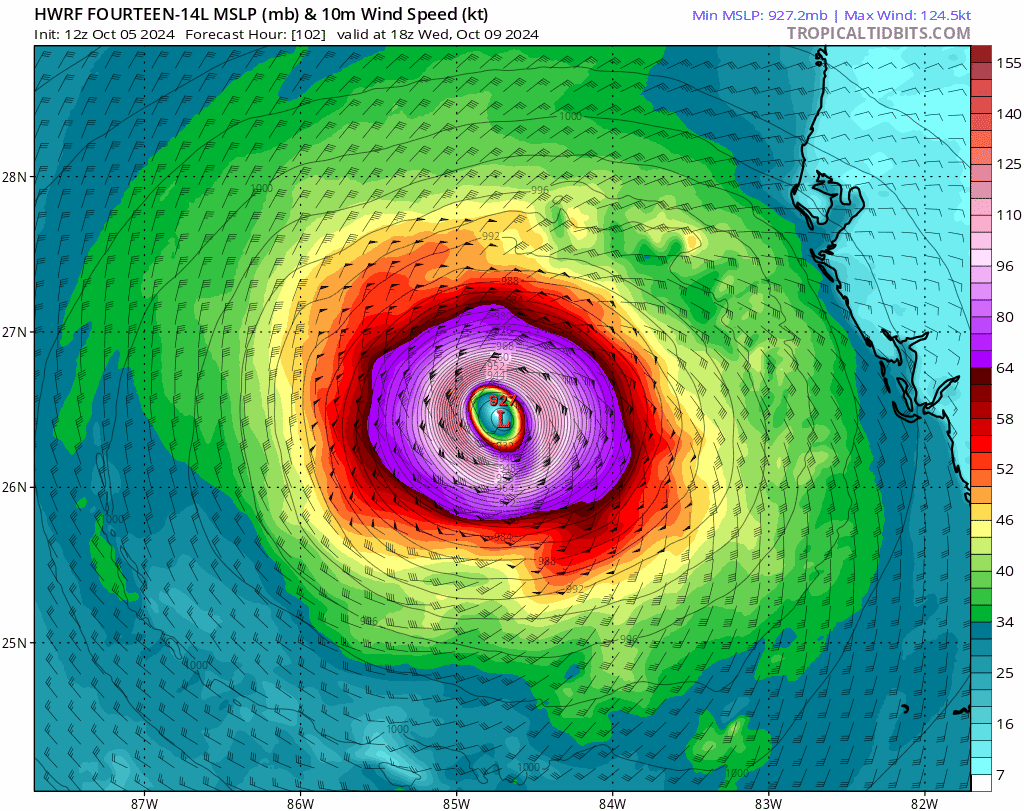
This is coming next week. Path is unclear, and its not as big as Helene, but anything near a 930mb in Tampa Bay and plowing over Orlando at 950mb, especially at this angle, is a catastrophe.
Katrina was 920mb at landfall, and these intensity forecasts have been undershooting hurricanes recently.
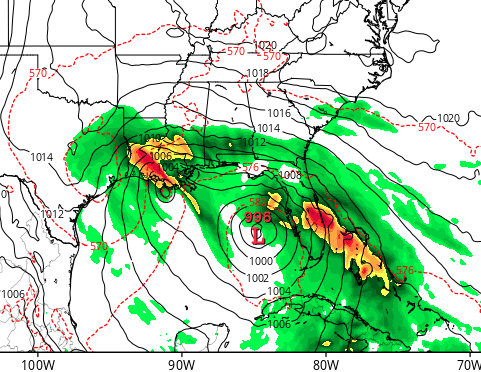
And there's another low pressure system at the edge of the GFS that I don't like, taking a similar path to Helene:
This is what the upcoming hurricane looked like a few days ago.
It's clearly trying to help the US by amputating the injured limb.
Good news! It's gonna get worse! Much, much worse! Say thank you to petrol states and companies, preferably by blowing up their infrastructure
And a big thank you to politicians blocking major efforts to reduce carbon emissions thanks to lobbying by the industry and foreign governments.
The world finally needs to stop politicans getting huge donations and hold them accountable for their actions.
But they brought a snowball into Congress and everything so obviously climate change is fake news!
Anything and everything for money... I wonder if they'll take cash in hell?
And also acting like "climate change" is a taboo topic that should never be spoken over the air, lest you offend someone.
Helene’s size shocked me but the storm surge for Katrina was unusually extreme. It was a well organized Category 5 and then weakened to a strong 3 right before landfall.
To compare with Helene, which was similar in terms of (east to west) diameter but covered much more area overall, with category 4 winds at landfall: the Weather Channel was making a big deal out of the 8ft storm surges. During Katrina, the Mississippi Gulf Coast had a 28 foot storm surge. (The Miss. Gulf Coast isn’t that geographically different from the Fla. big bend region but that plays a role too.)
Helene’s unusual movement speed kept it strong very far inland and caused massive issues in places that rarely see tropical weather. Harvey was the opposite: it stalled over Houston and dumped days of rain on a major metropolis.
I wish we could update the Saffir Simpson scale to something that takes into account more variables. There are other measurements but no storm is identical in terms of damage potential. A category 5 can not even make landfall whereas something like Hurricane Sandy was a category 1 (or equivalent since it wasn’t technically still a hurricane) when it hit NYC and caused massive damage and flooded subway systems. Sometimes, a storm hitting a place that isn’t used to them can knock over all the trees or flood rivers while a similar storm would be nothing to Miami or New Orleans.
What surprised me most about Helene was the ground speed. I don't remember seeing any hurricane make landfall in the US moving at over 20mph. As a casual observer I have anyways seen 12 mph as a quick storm and 6 mph as slow.
Yeah, I’ve lived in New Orleans or on the East Coast my whole life and don’t recall that sort of movement speed. Usually, you want a fast moving storm so no one area takes on all the rain but Helene was going so fast and was so massive that it’s probably unprecedented.
Helene is more deadly than Katrina if you don't count the deaths after the boat broke the levee that was well beyond its lifespan in New Orleans, which you shouldn't since that was a 100% fixable issue that was not taken care of.
We always say Katrina was a man-made disaster. I worry with climate change, that other places will be testing their infrastructure. Katrina should have been the canary in the coal mine and a lot of people just said, “Don’t live below sea level.” Old river damns can break just as easily as neglected levees.
Are these pictures even on the same zoom level?
You are correct, they don't appear to be. This one seems more accurate there, but the difference is still stark:
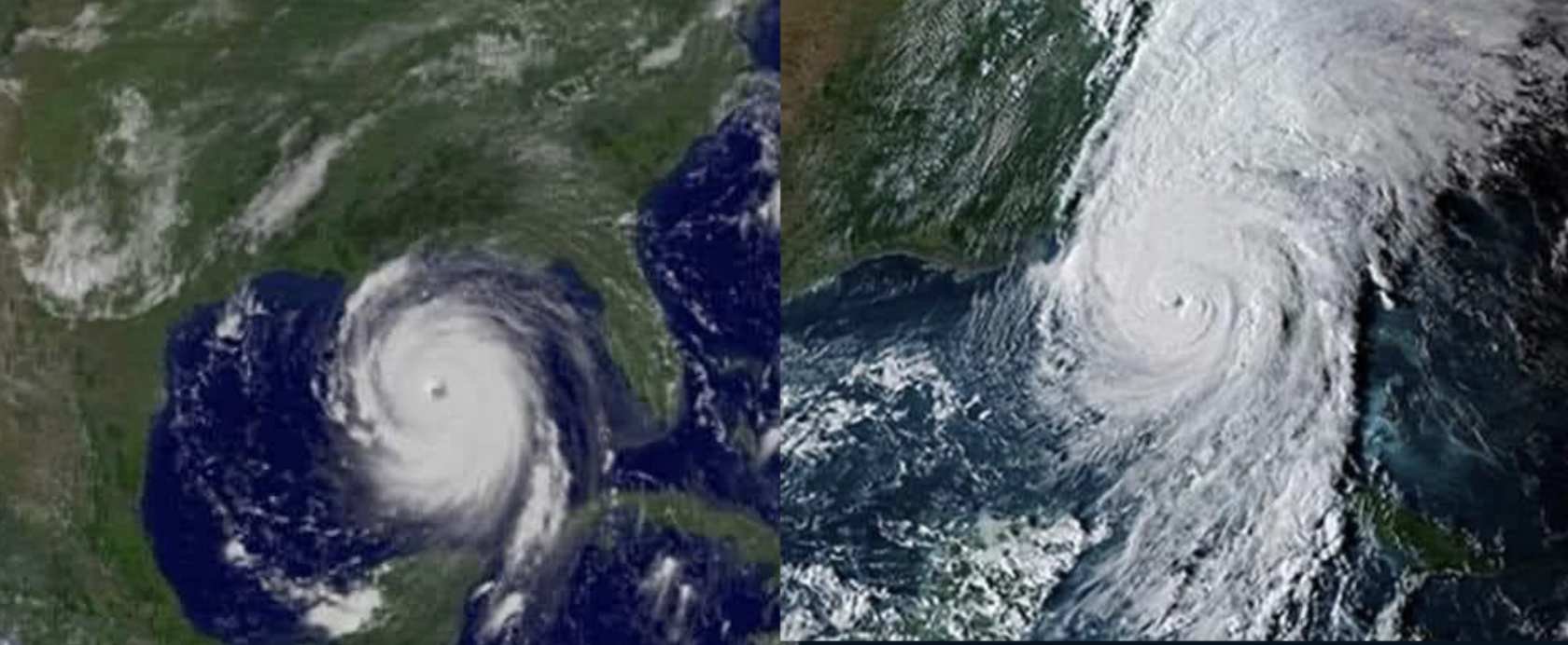
I was going to correct you on the comparison and I tried making my own scaled image .... but I couldn't because yours is a correct scale
I just couldn't believe that Helene was that massive and widespread compared to Katrina which was known as a major event. wow
They are not, but I think the main focus is on how obscenely tall Helene was. There's many parts of the US that weren't prepared because they didn't think it would reach them
It was ridiculously huge. I'm in Orlando, and when we were getting the first bands of wind, the eye of the storm was still over the Yucatán peninsula in Mexico
There were warnings for Georgia and the southern Appalachia, but the storm moved so much faster at the end and carried so much water inland. The ability to hold more water in the atmosphere has been an ongoing concern from climate scientists, and this is a clear example of how it can lead to disaster.
Not sure what the science is between 2 images with no source or timestamp and nearly 20 years of technological improvement between them is but this isn't the peak of Katrina
Katrina ultimately reached its peak strength as a Category 5 hurricane on the Saffir–Simpson scale on August 28. Its maximum sustained winds reached 175 mph (280 km/h) and its pressure fell to 902 mbar (hPa; 26.63 inHg), ranking it among the strongest ever recorded in the Gulf of Mexico.
It probably refers to its stats at landfall
Katrina weakened to a Category 3 before making landfall along the northern Gulf Coast, first in southeast Louisiana (sustained winds: 125mph) and then made landfall once more along the Mississippi Gulf Coast (sustained winds: 120mph). Katrina finally weakened below hurricane intensity late on August 29th over east central Mississippi.
But power doesn't equal damage for weather
[Katrina] is the costliest hurricane to ever hit the United States, surpassing the record previously held by Hurricane Andrew from 1992. In addition, Katrina is one of the five deadliest hurricanes to ever strike the United States
Sources:
https://en.m.wikipedia.org/wiki/Meteorological_history_of_Hurricane_Katrina
It’s also good to remember that Katrina’s storm surge and the subsequent failure of the levees and flooding of the city is what was so damaging.
Besides the wind and rain the destruction of the levees took a huge toll on New Orleans.
Wow, so according to MTG, I guess Democrat technology has really advanced over the past few years!
Not necessarily. They might just be able to choose the strength at will and decided not to start out with the max output back with Katrina.
Helene looks like a thrice-divorced hurricane.
I think we’re just a few years away from the planetary cyclones in Day After Tomorrow.
I want someone to project that map onto a globe to illustrate how ridiculous it was. The elegantly circular arcs of the north sides of those storms would look bizarrely teardrop-pinched, if I'm not mistaken.
W must be watching with popcorn
Really interesting. Is there a source for the pictures and data to share with friends?
I do not have a good source for that particular picture, but here are lots of links for you:
https://www.axios.com/2024/10/04/hurricane-helene-deadliest-us-storms-death-toll
Science!
I see Yoda in the 2nd pic